Aiguille du Midi : Vallée Blanche classic route
Fusionner des documents
Attention, les photos associées ne seront pas supprimées et deviendront orphelines.
Si vous souhaitez juste modifier le titre ou les documents associés (ex : déplacer une sortie vers un autre itinéraire), il suffit de modifier le document.
Si ce document est un doublon comportant des photos, demandez @Modo_Topo_FR de fusionner les doublons pour déplacer les photos sur le document conservé.
Points de passage
Itinéraires
Articles
Images

")


Rapports incidents/accidents
Description
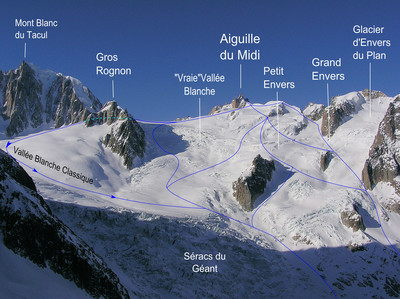
From the top of the Aiguille du Midi tram, traverse a system of concrete tunnels to reach the beginning of a well marked ridge (small party ledge at the start). Descend it for 200 meters carrying your skis, crampons may be useful. The slope becomes less steep and broader (classic ski route start).
Descend a first slope for 100 meters (east) then go diagonally towards the south to pass to the west of spot elevation 3550 over not very steep slopes. First follow these slopes towards Col du Midi then go diagonally towards the east to reach the base of the rocks resulting from spot elevation 3541 (western end of Gros Rognon). Descend to the South via gentle slopes towards the base of Pyramide du Tacul. Go diagonally towards the east, pass under the Vallée Blanche gondola then head towards La Bédière (north) around 3000 meters. You reach the lower base of the Petit Rognon, the slope becomes steeper and crevassed. Stay well to the left of Séracs du Géant.
Traverse to the north towards Requin refuge while remaining on the left bank of the glacier (crevassed section and exposed to serac falls). Pass under Requin refuge to reach "la Salle à Manger". Around 2450 meters, traverse Tacul glacier towards the east to reach its right bank. Follow it until a flat section then head towards the centre of the glacier. You reach Mer de Glace and follow it via easy slopes up to the level of the gondola while remaining primarily on the left bank.
To descend to Chamonix there are two solutions: - Via the gondola and the Montenvers train, - on skis (1h15) if snow conditions permit it. Follow the glacier in its centre until around 1700 meters. Then approach its left bank (steep sequence) to leave it around 1600 meters. Then you need to take off your skis and carry them for 15 minutes (increase of 50 meters) to reach Cabane des Mottets (located at spot elevation 1638). Then follow the trail called "Sortie Vallée Blanche" on the map until Chamonix.
Remarques
To descend until Chamonix on skis, the beginning of season (January, February) is better
Crevasses at the level of Séracs du Géant. Sequence exposed to the serac falls between Séracs du Géant and Salle à Manger.
Access:
Blanche Chamonix motorway. Aiguille du Midi tram at the entrance to Chamonix. Return to Chamonix on skis or by the Montenvers train
Accommodation:
The Aiguille du Midi tram is often very crowded. It is possible to book a place for the ascent at 08.92.68.00 67.
Matériel
Glacier equipment (ice axe, a pair of crampons at least for the group, rope, safety equipment) is indispensable. GPS and navigation instruments in the event of overcast weather.
Accès en transport en commun
Arrêt : Centre Technique (Chamonix-Mont-Blanc)
Distance avec le point d'arrêt du topo : 3.65 km
Voir le détail des lignes
Arrêt : Auberge de Jeunesse (Chamonix-Mont-Blanc)
Distance avec le point d'arrêt du topo : 3.8 km
Voir le détail des lignes
Arrêt : Chemin du Cerro (Chamonix-Mont-Blanc)
Distance avec le point d'arrêt du topo : 4.09 km
Voir le détail des lignes
Itinéraires associés

")


Commentaires
Ce contenu est sous licence Creative Commons BY-SA 3.0
Les images associées à cette page sont disponibles sous la licence spécifiée sur le document d'origine de chaque image.
Imprimé le 7 août 2025 04:08