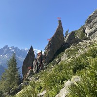
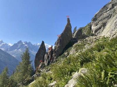
Aiguillette d'Argentière : Arête NE intégrale (La Biscante)
Qualité du document bon
Modifier le document
Versions
Signaler un problème
Fusionner des documents
Attention : cette action est irréversible !
Fusionner un document source avec un document cible transfère toutes les associations du document source au document cible, et définit une redirection du document source vers le document cible. Les commentaires doivent être transférés manuellement dans Discourse avant de fusionner les documents.
Document à fusionner (source) :
Aiguillette d'Argentière : Arête NE intégrale (La Biscante)
( 276031 )
Document à conserver (cible) :
Supprimer ce document
Attention : cette action est irréversible !
Êtes-vous sûr(e) de vouloir supprimer ce document ? Attention, les photos associées ne seront pas supprimées et deviendront orphelines.
Si vous souhaitez juste modifier le titre ou les documents associés (ex : déplacer une sortie vers un autre itinéraire), il suffit de modifier le document.
Si ce document est un doublon comportant des photos, demandez @Modo_Topo_FR de fusionner les doublons pour déplacer les photos sur le document conservé.
Supprimer cette version linguistique
Attention : cette action est irréversible !
Êtes-vous sûr(e) de vouloir supprimer cette version linguistique ?Itinéraires

Rapports incidents/accidents
Activités
Type d'itinéraire boucle (pied de la voie)
Durée 1 jour(s)
Type de rocher gneiss
Type de voie grande voie
Configuration arête, face
Cotations
D-
5b>5b
I
P1
Altitude maximale
1893
m
Dénivelé +566 m / -528 m
Dénivelé des difficultés
100
m
Dénivelé de l'approche
450
m
Description
Approach
From the roadside parking at Tré les Champs, follow the path leading under the Chéserys slabs and in the direction of Lac Blanc. Before the ladders you arrive at the two Aiguillettes d'Argentière. The two routes climb the taller, (Grand), pinnacle.

Route 1
The normal route goes up the SW ridge of the taller pinnacle, 25m 4c
Route 2
The « Biscante » goes up the NE ridge of the taller pinnacle, starting at the foot of a slab.
| L1 | 4b | 6 bolts | Start up the slab to a « table »boulder. |
| L2 | 5a | A rock fault to step over, (easy), then a 10m abseil. | |
| L3 | 4c | Up the slab slightly to the right of the crest, then up to a belay ledge on the crest of the ridge. | |
| L4 | 5b | Many bolts | Exposed pitch. Continue up the crest of the ridge until it becomes almost vertical. Traverse across the face to the right , around a rib, to reach the SW face and so to the top. |
Descent
25m abseil from the big ring on the top.
Remarques
- Well bolted
- Biscante was the nickname of Louis Lachenal
Matériel

Dernières sorties
Commentaires
Ce contenu est sous licence Creative Commons BY-SA 3.0
Les images associées à cette page sont disponibles sous la licence spécifiée sur le document d'origine de chaque image.
Imprimé le 16 juillet 2025 00:41