Gastlosen : Le Chat
Fusionner des documents
Attention, les photos associées ne seront pas supprimées et deviendront orphelines.
Si vous souhaitez juste modifier le titre ou les documents associés (ex : déplacer une sortie vers un autre itinéraire), il suffit de modifier le document.
Si ce document est un doublon comportant des photos, demandez @Modo_Topo_FR de fusionner les doublons pour déplacer les photos sur le document conservé.
Points de passage
Livres
Itinéraires
Articles
Images
Rapports incidents/accidents
Historique de l'itinéraire
Who – When? Bernhard Witz, Simon Savoy, Jérémy Folly and Samuel Pillet, summer 2009. First Full-Man : Bernhard
Description

General Access
(Google Map)
From Bulle, drive to Charmey, and go until Jaun (Bellegarde). Turn right at roadsign "skilift" and follow roadsign "Chalet du Soldat". Go until the end of the road, and park there. From there take the Chalet du Soldat footpath, you will see a alpine chalet. 80m before a big right curve, turn left into a small footpath (stone mark "Col d'Oberberg"). Walk until (hard) the base of the Pfadflue, and go left to the Oberberg pass. Once there, follow N-E on the same slope of the mountain, and take the first grass slope that leads to the pass between the Petit Pouce (lit. Little Thumb) and the Eggturm. Bypass the Petit and Grand Pouce (lit. Great Thumb) taking N-W, then a few climbing steps lead to the pass between the Grand Pouce and the Chat (lit. Cat).
Where?
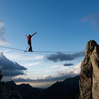
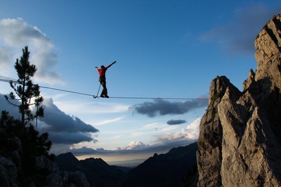
Betwein the south ear of the Chat (Cat) and the Grand Pouce
Linking
It is easy to throw the webbing from the Chat and walk up with on the Grand Pouce.
Tension
Pulley system is ideal, but why not a Primitiv.
Ancrage 1
Chat side: You climb a 6a pitch oriented on S-E (belay under the ears), or climb on the right, easier. A long spanset around the ear for the line, and a spit and a bolt hanger on the top of a route behind the other ear for backup.
Ancrage 2
Grand Pouce side: From the pass the Grand Pouce summit is very easy. 2 bolt hangers horizontally placed for the line, over the fir, and 2 more aligned for backup further.
Remarques
Possible to sleep under cover at the Oberberg pass (overhanging roof), or to the parking. The approach is an hour long. An other footpath goes right there (forest track in a curve on the right of the Chalet road), but the end is really unpleasant. We did it, and I do not recommend it.
A lot of other possible highlines, from short to long, with great atmosphere.
Ressources externes
Imported from the Highline Database
Pictures and text from Jeremy Folly. Many thanks to him.
Pictures: http://picasaweb.google.com/jejefolly/LeChat
Questions ? jeremy . folly at bluewin . ch
Commentaires
Ce contenu est sous licence Creative Commons BY-SA 3.0
Les images associées à cette page sont disponibles sous la licence spécifiée sur le document d'origine de chaque image.
Imprimé le 11 août 2025 03:42