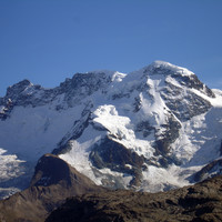
Breithorn W : Normal route from Klein Matterhorn
Fusionner des documents
Attention, les photos associées ne seront pas supprimées et deviendront orphelines.
Si vous souhaitez juste modifier le titre ou les documents associés (ex : déplacer une sortie vers un autre itinéraire), il suffit de modifier le document.
Si ce document est un doublon comportant des photos, demandez @Modo_Topo_FR de fusionner les doublons pour déplacer les photos sur le document conservé.
Points de passage
Livres
Itinéraires
Articles
Rapports incidents/accidents
Has to be one of the easiest 4000m peaks. Good for acclimatization.
Historique de l'itinéraire
First ascent: 13.08.1813, Henry Maynard with guides Joseph-Marie Couttet, Jean-Baptiste and Jean-Jacques Erin, Jean Gras.
Description
Approach.
Take the lift system to the Kleine Matterhorn station
Route 1h30
From the station, go to point 3795m and traverse the Breithorn plateau (about 3800m) curving around ENE to the foot of the S face. Cross the bergschrund and go up from right to left to reach the W ridge, which you follow to the summit,(4164m)
(From the Testa Grigia, count on 2h30)
Descent
Several options: e.g.
1. By the ascent route
2. By traversing the summit: descend the exposed E ridge to the col 4135m between the W and central summits
From the col, make a return trip to the central and E summits (4159m) by a corniced ridge. A good 30mins for the return trip.
Once back at the col, go to the Breithorn plateau by the S face to rejoin the ascent route.
Remarques
A sudden change in the weather can cause route finding problems on the plateau.
Possible to start on foot from Zermatt.
A good first 4000m peak, though the ski pistes detract from the mountain feel.
Matériel
Ski and snowboard touring, snowshoeing
Alpine snow, ice and mixed climbing from F to PD+
Crevasse rescue gear
External resources
Ressources externes
- The Breithorn by Edward Schweitzer, Peaks, Passes, and Glaciers, II, vol. 1, 1862, p. 343-382 : account of an ascent, September 2, 1861.
Accès en transport en commun

We didn't find any public transport stop point in a 5 km foot range from any route access point.
Itinéraires associés

Commentaires
Ce contenu est sous licence Creative Commons BY-SA 3.0
Les images associées à cette page sont disponibles sous la licence spécifiée sur le document d'origine de chaque image.
Imprimé le 28 juillet 2025 02:09

