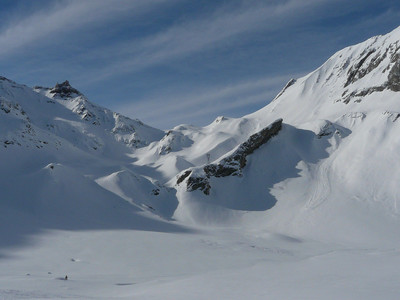
Col du Bonhomme : from Notre Dame de la Gorge
Fusionner des documents
Attention, les photos associées ne seront pas supprimées et deviendront orphelines.
Si vous souhaitez juste modifier le titre ou les documents associés (ex : déplacer une sortie vers un autre itinéraire), il suffit de modifier le document.
Si ce document est un doublon comportant des photos, demandez @Modo_Topo_FR de fusionner les doublons pour déplacer les photos sur le document conservé.
Livres
Articles
Rapports incidents/accidents
Description
Ascent
From the parking just beyond the Telecabine de la Gorge, cross the Bon Nant river and go along the track for 300m to opposite Chapelle de Notre-Dame de la Gorge 1210m, (bridge.)
Go up the track on the true right bank, (Roman road, often iced, crampons sometimes useful!) You cross a Roman bridge, (worth a closer look) to reach the hamlet of Nant Borrant and a long flat area, la Rollaz (1530m). Follow the track until La Balme (1706m, (private hut, closed in winter and spring).
Climb up a little shoulder to the SW of the chalets then to the S to near a pylon. (Keep to the left to avoid avalanches coming down from the Roches Franches to the right). Descend a little, behind the pylon and by a short traverse reach the flattish area of the Plan Jovet.
Go up to the SE and bypass a large rock band by a little shoulder on the true right bank of the Bon Nant, (until Tumulus 2043m). Traverse the Plan des Dames to the S then go up a little cwm more steeply to the SW. At 2250m go at an easier angle to the S to reach the col.
Descent
By the same route. Depending on conditions, one can ski down most of the gullies and snow bowls to the Plan Jovet.
Remarques
The Roman road down to the chapel is often impossible to ski; a sheet of water ice with protruding rocks!
To long flat sections (Plan Jovet et la Rollaz) Enter them at maximum speed to minimize the poling.
An extension towards the Tête N des Fours possible.
Matériel
Crampons may be useful for the Roman road, (especially early in the season).
Accès en transport en commun

We didn't find any public transport stop point in a 5 km foot range from any route access point.
Itinéraires associés

Commentaires
Ce contenu est sous licence Creative Commons BY-SA 3.0
Les images associées à cette page sont disponibles sous la licence spécifiée sur le document d'origine de chaque image.
Imprimé le 28 juillet 2025 23:35

