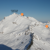
Pointe de Chalune : Via the Combe du Foron
Fusionner des documents
Attention, les photos associées ne seront pas supprimées et deviendront orphelines.
Si vous souhaitez juste modifier le titre ou les documents associés (ex : déplacer une sortie vers un autre itinéraire), il suffit de modifier le document.
Si ce document est un doublon comportant des photos, demandez @Modo_Topo_FR de fusionner les doublons pour déplacer les photos sur le document conservé.
Itinéraires
Articles
Rapports incidents/accidents
Description
From the hamlet of Bonnavaz (1187m) or Encrenaz pass (1433m), follow the road until the Foron chalets (1355m). Then go up the scoop of Foron towards the NW first passing Foron du Milieu (1499m) then Foron d'en Haut (~1680m) located at the base of a small plateau. Always traverse this plateau towards the NW and reach slightly on the right the Foron pass (1832m).
Via an ascending traverse on the left (SW), you reach the Chalune pass (1896m) which gives access to the SSE face of Pointe de Chalune. Climb directly N to reach the E ridge, which is broad and not very inclined, follow it as far as the Chalune summit.
Descent: two possibilities: -by the uphill route (classic route); -via the broad SSE face of Chalune and the traverse of the Bolire pass(1649m) which makes it possible to reach the scoop of Foron. Very short sections of S4 if you start directly from the summit on skis.
Remarques
The starting altitude from Encrenaz pass (1433m) is higher than that of Bonnavaz (1187m) and the Foron chalets (1355m). The route starts with an 80m descent on the road that you have to go back up on the way back.
The round trip by the way up route (scoop of Foron) is very classic and not difficult: PD -, S2 with S3 sections. The descent of the SSE face is more unrelenting: almost 35°/250m after le Labande. Some slightly steeper and narrower sections but short and non obligatory to the start of the summit. PD +, unrelenting S3, sections in S4.
All the slopes face S to SE and thus are quickly exposed to the sun.
Access:
From Taninges, go to Les Gets via the Pont des Gets then Morzine/St Jean d'Aulps, Essert-Romand and finally Col de l'Encrenaz. If you start from from Bonnavaz, leave the Gets road at Pont des Gets and go towards Praz de Lys.
Accès en transport en commun
Arrêt : La Savolière (Taninges)
Distance avec le point d'arrêt du topo : 4.13 km
Voir le détail des lignes
!
At least one access point in the route don't have a public transport stop within 5km.

![[Concours Photo Sophie 2021] Face à vache dans le Chablais [Concours Photo Sophie 2021] Face à vache dans le Chablais](https://media.camptocamp.org/c2corg-active/1635355533_106912697MI.jpg)
Commentaires
Ce contenu est sous licence Creative Commons BY-SA 3.0
Les images associées à cette page sont disponibles sous la licence spécifiée sur le document d'origine de chaque image.
Imprimé le 28 juillet 2025 02:34


![[Concours Photo Sophie 2021] Face à vache dans le Chablais [Concours Photo Sophie 2021] Face à vache dans le Chablais](https://media.camptocamp.org/c2corg-active/1635355533_106912697SI.jpg)
